Lessons & Units
A database
of lessons and units searchable by content and cultural standards,
cultural region and grade level. More units will be available soon.
You can use Acrobat Reader to look at the PDF version of the Cover
Sheet
for the Units and Self-Assessment
for Cultural Standards in Practice.
Winds
And
Weather
by Jonas Ramoth and Sidney Stephens
Activity Series 5 - Global Winds*
| Summary |
In this activity, students extend their
understanding of convection to consider global winds and the effect of
the earth's rotation on the creation
of patterns of prevailing wind direction. |
| Concept |
The rotation of the Earth and global convection currents create
prevailing wind patterns at different Earth latitudes. Above the Earth's
surface, the gases of the atmosphere flow in great cycles of weather and
the longer patterns of climate. These cycles are primarily driven by energy
from the sun. More heat energy from the sun falls at the equator than at
the poles, and thus air in the tropics is heated and rises. If the earth
did not rotate, this warm equatorial air would rise, cool off and sink at
the poles creating high-altitude winds from equator to pole, and low altitude
winds from pole to equator in the pattern of the familiar convection cell.
Such pole to equator winds do not prevail, however, because the rotation
of the earth breaks this potential north-south convection cell into 3 cells
in each hemisphere. |
| Activity 5a
Materials |
20 cm diameter cardboard circles
Pencils
Water
|
|
Procedure
Gear-Up:
|
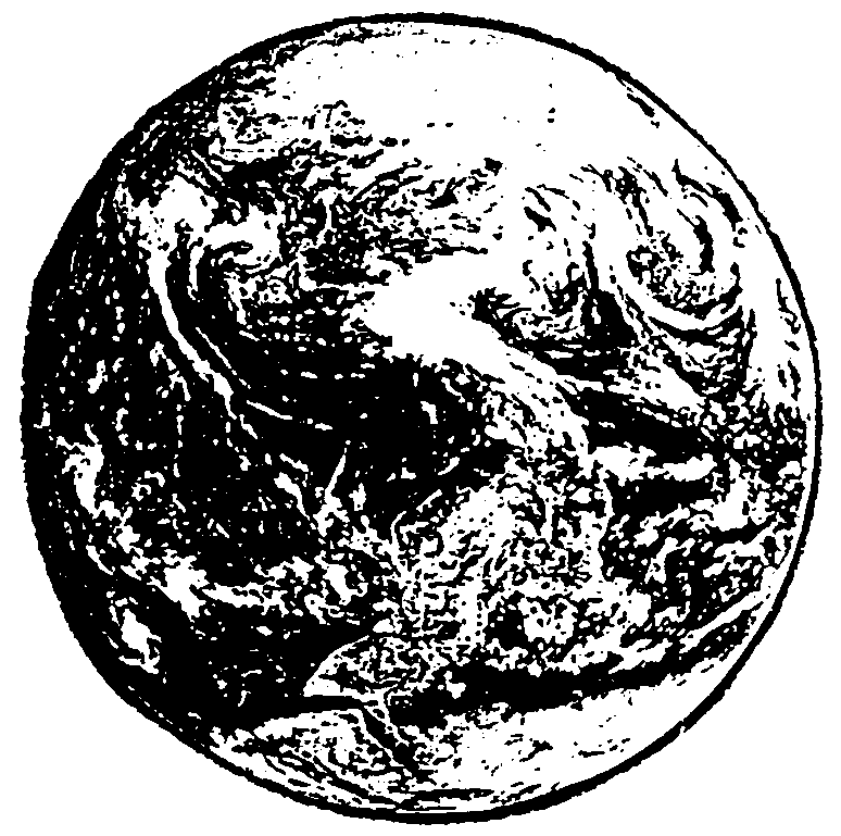
1. You know from your local studies that cloud movement often indicates
the direction of the wind. Look at this photograph of the Earth taken from
space. What do you notice about the pattern of the clouds? (They're in swirls.)
What do you suppose this tells us about the direction of atmospheric winds?
What are your ideas about why the clouds might be curving? |
 |
|
Explore/
Generalize:
|
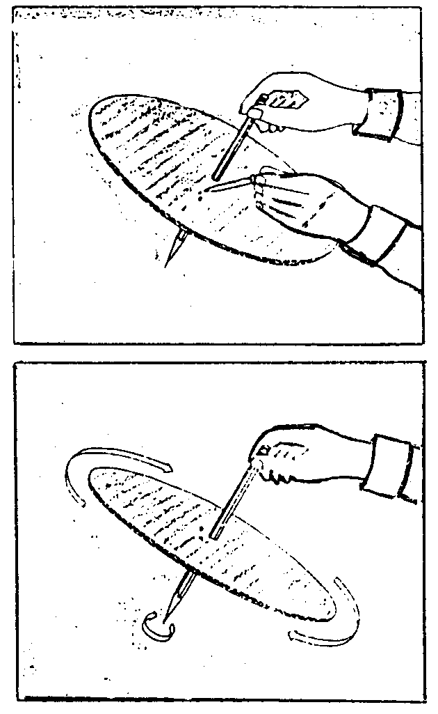
2. Let's see if we can find out what causes the swirl pattern in the
clouds. Obtain a circle of cardboard approximately 20 cm in diameter.
Push a pencil through the center of the circle. Tilt the cardboard to
one side. Place a few drops of water on the cardboard and watch the pat
they take as they move downward. Is the path curved or straight?
3. Now, put several drops of water on the cardboard circle and by twisting
the pencil spin the cardboard. How does the movement of the cardboard
affect the path of the water droplets?
4. Imagine that the water droplets are clouds that are being moved by
the wind. What could cause the wind to move in a curved path? (Polar winds
from the North come in contact with the Earth's surface. The Earth is
rotating at a speed faster than the wind. The speed of the rotating Earth
pulls on the Polar winds causing them to curve a bit from their straight
path. The swirl pattern in the clouds is caused by this deflection of
the southward movement of the polar air currents).
|
| Activity 5b
Explore/
Generalize: |
1. Looking down on the North Pole of a globe, spin the globe from the
west to the east -counter clockwise). Using a piece of chalk, have a student
attempt to draw a straight chalk line on the globe from the 35 degree
latitude line to the equator while the globe is spinning.
2. Stop spinning the globe and have students observe the chalk line.
Is the chalk line straight? In which direction does the chalk line curve?
In the Northern Hemisphere the Earth's rotation causes the wind to curve
toward the East. Below the equator the effect of the Earth's rotation
is reversed and the North moving winds are pushed to the West. The diagram
on the left shows the directions of the Earth's prevailing winds. Prevailing
winds are named for the direction from which they blow. Thus, the prevailing
westerly winds blow from the west towards the east and the prevailing
easterly winds blow from the east towards the west.
3. From looking at the diagram can you tell what direction the prevailing
winds blow across United States (the Lower 48)? How about prevailing winds
in Barrow? Selawik? Fairbanks? Anchorage? Juneau?
|
| Apply/Assess: |
4. From your local studies, how important are the prevailing
polar easterlies in Selawik? |
5. Looking at a globe and the prevailing winds diagram, identify
these areas:
|
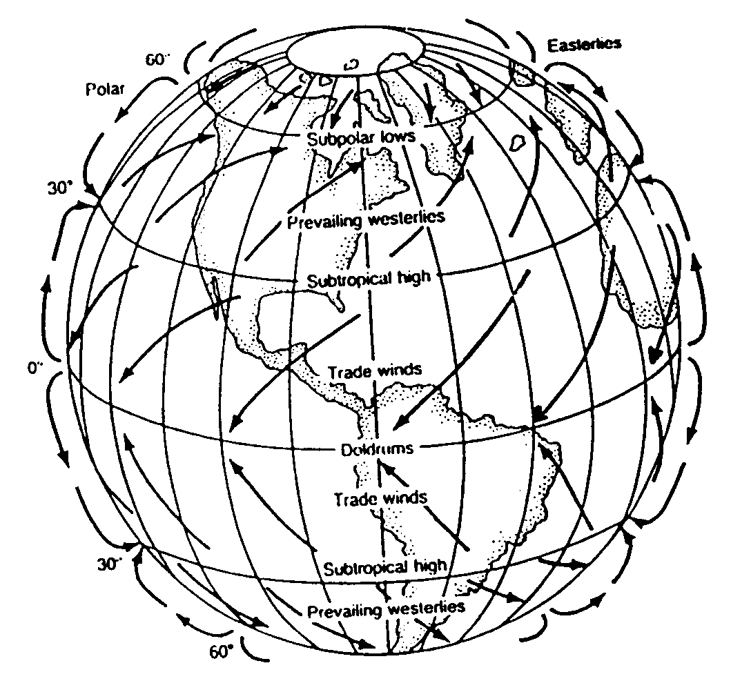 |
« The area where the northeast trade winds and southeast
trade winds don't quite meet, called the doldrums, is a calm area where
no wind or
very little wind blows. Sailing captains tried to avoid this area. Why?
« The area in the Atlantic Ocean at 30 N latitude was given the name
"Horse latitudes". This area is also very calm. Find the Horse latitudes
on the diagram. Spanish ships carrying horses to the New World colonies
were often stuck for long periods in these calm seas. When the horses
used up their share of thrown overboard to lighten the load and get the
ships moving again.
« If winds traveling over water bring moisture and
moisture is dropped in the form of rain when winds begin to rise over
mountains, where would
you expect rain forests to be in the United States? In South America?
|
6. If helium balloons were released from your school and were carried
away by winds, eventually popping with the remains drifting to the ground,
where would you expect to find the remains of these balloons and why?
Be sure to justify your answer using evidence from your studies.
* Adapted from Barr, B. (1994)
Standards
Section I - Observing Locally
Section II - Understanding Wind
Section III - Connecting
Globally
Appendix A - Selawik Weather Information from
Jonas Ramoth
Appendix B - Assessment
Appendix C - Weather Resource
List
Appendix D - Interdisciplinary Integration
Handbook
for Culturally Responsive Science Curriculum by Sidney Stephens
Excerpt: "The information and insights contained in this document will be
of interest to anyone involved in bringing local knowledge to bear in school
curriculum. Drawing upon the efforts of many people over a period of several
years, Sidney Stephens has managed to distill and synthesize the critical ingredients
for making the teaching of science relevant and meaningful in culturally adaptable
ways." |