Alaska Native in Traditional Times: A Cultural Profile
Project
as of July 2011
Do not quote or copy without permission from Mike
Gaffney or from Ray Barnhardt at
the Alaska Native Knowledge Network, University of Alaska-Fairbanks. For
an overview of the purpose and design of the Cultural Profile Project, see Instructional
Notes for Teachers.
Mike Gaffney
Chapter Seven
“Worldview” Deserves
Special Attention
Worldview – belief system, ceremonial practices, shamanism,
core values, cultural identity, historical legacy
An Alaska Native Worldview
The past illuminates the present. We have said that worldview is the heart of our
concept of culture and therefore deserves special attention. Now it is time for you to give it that
special attention by exploring how your selected Native group or groups made sense of their
spiritual, natural, and social worlds, and the rules for conducting themselves in these worlds.
This exploration should tell us much about their cultural identity and how it was shaped by core
beliefs and valued traditions.
But first recall that one purpose of the Cultural Profile Project is to show how the study
of traditional times can help us better understand modern Alaska Native life and civic affairs. We
highlighted the connection between the distant past and the present when we discussed the
historical research required when a tribe applies for federal recognition. And again when we
discussed how Native aboriginal title served as the legal basis for Tlingit and Haida land claims
and for ANCSA. Yet it may surprise you to know that understanding the spirituality of
traditional Alaska Native worldviews can also have practical application in modern times. To
illustrate this connection, we go to the Alaska Supreme Court case of Carlos Frank v. State of
Alaska and the story it tells.1
In 1979, Carlos Frank and several other Athabaskan Indians from Minto were arrested for
taking a moose out of season for the purpose of providing ritually required moose meat at a
funeral potlatch. Mr. Frank and his legal counsel argued that the funeral potlatch is a religious
event dating from traditional times and the consumption of moose meat has always been an
essential ritual of this spiritual activity. They said that to apply this “game regulation to him,
under the circumstances, amounted to an abridgement of his freedom of religion,” hence a
violation of his constitutional rights under the First Amendment. Before appeal to the Alaska
State Supreme Court, the case was heard in district court.
Alaska’s Attorney General countered Frank’s defense with three arguments. First, while
the consumption of moose meat at a funeral potlatch is highly desirable, it is not an absolute
necessity. Secondly, The State of Alaska has a “compelling state interest” in applying the rules
of fish and game management equally to all Alaska residents. And thirdly, the regulation of fish
and game is closely watched by many Alaskans passionately involved in hunting and fishing
activities. It is, the Attorney General said, predictable that any exception made for one class of
people is sure to set off a firestorm of anger, protest, and possible “lawlessness.” Therefore this
potentially explosive situation only heightens the state’s compelling interest to deny any
exception to the rule, no matter the circumstance.
Using as precedent two decisions by the United States Supreme Court on questions of
religious freedom, the district court applied a three part test.2 First, was the funeral potlatch an
integral part of a “distinct belief system?” That is, was it an authentic religion? Secondly, was the
conduct of the hunters clearly tied to fulfilling a fundamental tenet of that religion? And thirdly,
was Carlos Frank a sincere believer in the religion? The lower courts agreed that the funeral
potlatch and its spiritual context clearly satisfied the first two parts of the test. As for the third
part, they easily found Mr. Frank to be a sincere believer.
So an interesting question becomes: What evidence convinced the district court that this
spiritual element of a traditional Athabaskan worldview constituted a religion as commonly
defined in modern times? Answer: The court was convinced by the considerable testimony they
heard from respected Athabaskan elders, including Chief Peter John of Minto, and from
distinguished scholars who had studied available historical documentation. The courts also found
that the oral history they heard was well supported by the written historical record. Even so, the
district court agreed with the state that “moose meat was not such an absolute necessity...as to
override the compelling state interest of the State of Alaska in the management and control of its
game for the benefit of all its people, Native and white.” Therefore Mr. Frank’s freedom to
practice a religion was not abridged, and the state has the right to impose the appropriate penalty
for his violation of fish and game laws.
On appeal, the Alaska Supreme Court reversed the district court’s ruling. The Court held
that “absolute necessity” is too strict a standard when judging a freedom of religion case. The
fact that moose meat consumption at a funeral potlatch was a deep and abiding spiritual tradition
was cause enough to allow an exception to the game regulation. Moreover, the state’s interest in
maintaining healthy moose populations is not compromised by such rare, religiously based
exceptions. As for the state’s prediction of civil disobedience and possible lawlessness if an
exception is allowed, the Court found no evidence supporting this assertion. The Court went so
far as to say that such a suggestion insulted the people of Alaska. After years of appeal, Carlos
Frank’s conviction was finally dismissed, and the angry protests predicted by the state never
occurred.
The past illuminates the present in the Carlos Frank case by showing that knowledge of
the past – of a traditional Native worldview – can help explain aspects of Native beliefs and
behavior in modern times. Mr. Frank would have been convicted if the Alaska courts had felt the
oral and written testimony they received on Athabaskan traditional spirituality lacked historical
credibility. Perhaps an event more to the point occurred in 2009 when the taking of moose for
memorial potlatches again became a public policy issue. This time the question was not whether
moose could be taken out of season for a memorial potlatch, but where the taking could take
place. The Department of Public Safety interpreted state game regulations to say that even the
taking of moose for religious purposes had to be done in state designated subsistence hunting
areas away from urban centers. Citing the Carlos Frank decision of 1979, the Alaska Board of
Game ruled otherwise. The Board determined that such a restriction would still be an
abridgement of religious freedom. But at the same time it is reasonable to require potlatch
hunters in non-subsistence areas to first obtain authorization from the nearest Fish and Game
office.
An “intricate subsistence-based worldview.” Dr. Oscar Kawagley’s book, A Yupiaq
Worldview, continues to assist our work on this important subject by describing what he sees as
the Yup’ik worldview and how it conflicts with the Western, Euro-American worldview. He
suggests that the fundamental elements of the Yup’ik worldview have much in common with all
other Alaska Native worldviews. He further suggests that when compared to the Western
worldview, what differences may exist melt away. Therefore we want to pay close attention
because he is telling us what to look for in our own cultural profile research.
Dr. Kawagley actually gives us an instructional guide for conducting our research. First
and foremost, he emphasizes an intricate subsistence-based worldview as the overarching
concept. What he means is that the elements of the traditional Native worldview flow from a
subsistence way of life as opposed to an urban-industrial way of life or a rural agricultural way
of life or any other way of life. He points out, for example, that a major element of the traditional
Native worldview was proper respect and behavior toward the natural world, particularly toward
the body and spirit of animals. Since Native life was totally dependent on fish and game, it
should not surprise us that over time certain animals took on mythical qualities and spiritual
meanings for the people directly dependent on them. These animals were, after all, the ultimate
givers of human life.
In the following passage from his book you will find other important elements of the
Native worldview emphasized in italics. You only have to make a list of these elements to know
what to look for when researching the worldview of your Native group. These elements are
myths (for example, the role of Raven in creation stories), rituals, ceremonies, role of elders, and
everyday core values such as responsibility, awareness, harmony, and reciprocity. Here is that
passage:
Alaska Native peoples have traditionally tried to live in harmony with the world
around them. This has required the construction of an intricate subsistence-based worldview, a complex way of life with specific cultural mandates regarding the ways in
which the human being is to relate to other human relatives and the natural and spiritual
worlds.
Citing the works of several scholars, He continues:
This worldview, as demonstrated historically by the Native peoples of Alaska,
contained a highly developed social consciousness and sense of responsibility. As
indicated by the writings of outside researchers and observers, Native peoples’ myths,
rituals, and ceremonies were consistent with their relationship to one another and to their
environment...
Wisdom, insight, knowledge and power were considered the prerogative of the
elders, who were honored and respected in recognition of their achievements. Attitude
was thought to be as important as action; therefore one was to be careful in thought and
action so as not to injure another’s mind or offend the spirits of the animals and
surrounding environment. For one to have a powerful mind was to be “aware of or awake
to its surroundings.”
To help practitioners along this reciprocal path, Native peoples developed many
rituals and ceremonies with respect to motherhood and child rearing, care of animals,
hunting and trapping practices, and related ceremonies for maintaining balance between
the human, natural, and spiritual realms. This intricate sense of harmony with all things
has been identified by most observers as central to understanding Alaska Native
worldviews ...
Fienup-Riordan has called the Alaska Native and other indigenous peoples the “original ecologists.” One reason for this is that their worldviews are dependent upon
reciprocity — do unto others as you would have them do unto you. All of life is
considered recyclable and therefore requires certain ways of caring in order to maintain
the cycle. Native people cannot put themselves above other living things because they
were all created by the Raven, and all are considered an essential component of the
universe. [Emphases ours] 3
Professor Kawagley then gives us an Iñupiaq example of how significant elements of a
worldview are passed on to future generations. Within the following short story by Mary
Muktoyuk are many of the points emphasized in the above passages. He says that “out of this
ecologically based emphasis on reciprocity, harmony, and balance have evolved some common
values and principles that are embedded in the worldviews of Alaska Native people.” From Mary
Muktoyuk’s Iñupiaq Rules for Living, here is the story:4
Back then, my parents would give us lessons on correct behavior, back when I
was first becoming aware. My parents spoke with great wisdom of things that we did not
know about.
Also, when we were small, from time to time someone would kill a polar bear.
The people were very happy when a hunter killed a polar bear, for polar bears were
considered extremely dangerous then. Then after they had slept a certain number of
nights, they would give thanks for it by dancing. They would give thanks for the polar
bear.
Then they would give some pieces of skin for sewing to those who were growing
old, and they gave them food, too, because they were thankful for that polar bear and were
celebrating it. They tried to make those who were growing old happy, too. These days,
people are no longer like that, because we are no longer in our land, and because those
wise people of long ago have died, all of them. They would give freely of food or skins for
sewing. In those days, they gave and gave freely. They lived a good life then. These days,
they no longer live in a good way, for they are no longer as they used to be.
The elders, in those days, we held in great respect. Whatever they told us, we
would listen very carefully, trying not to make mistakes when we listened, because we
respected them so highly, because they knew much more than we did while we were still
growing up. In these times, though, people seem to have stopped doing things in the old
way. It is known that they no longer do things as they used to. (9-10).
Dr. Kawagley employs an interesting device for summarizing the Native worldview. He
calls this device a tetrahedral metaphor based on the geometric concept of a polygon. A polygon
has three or more sides connected in such a way that no two lines cross. The simplest polygon is
the triangle. A tetrahedron is a polygon with four line segments or “faces.” The Egyptian and
Mayan pyramids are good examples of a polygon structure. Below is his tetrahedral structure of
the Native worldview and his explanation of what it illustrates.
Oscar Kawagley’s Tetrahedral Metaphor.
Figure 7-1
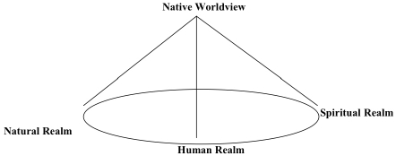
To help illustrate the interrelationship among human nature, nature, and super nature
(or spirituality) in the Yupiaq worldview, I will utilize a tetrahedral metaphor... If we use
the three corners of the base to represent the human being [including human social
organizations], nature, and spirituality respectively as elements in a common circle of
life, we can see the apex as representing the worldview that overarches and unites the
base elements of our existence. The lines connecting these “poles” can be seen as the life
forces that flow all ways between and among the human, spiritual and natural worlds and
are united through the worldview. The three base poles all provide essential supports to
the Yupiaq worldview...The Yupiaq would agree with Chief Seattle (1790—1866), who
stated that “This we know: the earth does not belong to man, man belongs to earth. All
things are connected like the blood that unites us all. Man did not weave the web of life,
he is merely a strand in it. Whatever he does to the web, he does to himself” (Kawagley,
pp. 15-17).
Ceremonies. We can get a good idea of a people’s worldview by examining their rituals
and ceremonies. A “ceremonial cycle” provides a cultural window through which to glimpse less
visible core cultural values of the group. Take what might be called the yearly ceremonial cycle
of Americans. An African anthropologist from, say, the Nation of Botswana in Southern Africa
can get some idea of American values and traditions by asking about the meaning of our holidays
and how they are actually celebrated. Among others, there is Presidents Day, Independence Day
(fourth of July), Columbus Day, Veteran’s Day, Martin Luther King Day, Memorial Day, Labor
Day, Thanksgiving, and Christmas. For an Alaska Native example, we go to the work of the
anthropologist Ann Fienup-Riordan. She has described five major feasts and festivals making up
the traditional winter ceremonial cycle of the Central Yup’ik. There is the Bladder Festival, the
Feast of the Dead, the Gift Festival, the Messenger Feast, and the Masquerade Festival. As with
American holidays, the question becomes: What aspects of Yup’ik culture is being celebrated by
these holiday feasts? So be sure to look for similar ceremonial activities of your selected group.5
Shamanism: A Comparison
Alaska and Siberia. A cultural profile of a Native group’s traditional worldview is not
complete without a description of their spiritual leadership. Here we are talking about what is
usually called shamanism, although there are some Athabaskans who prefer the designation,
medicine man or medicine woman. The term shaman apparently comes from the language of a
Siberian Native group, the Evenk, and means “ones who knows.” Rather than start with an
example of traditional shaman duties and practices from Native Alaska, let’s look at a brief
description of shamanism as generally practiced among the twenty-two indigenous Native
cultures of Siberia.
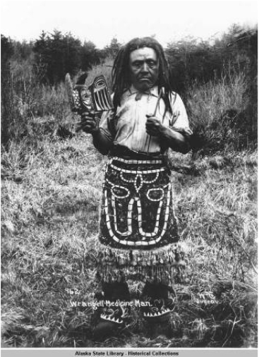
Figure 7-2
Evenk Shaman of Siberia6
But, you may ask, why go abroad when our specific interest is Alaska Natives? We
broaden our knowledge and sharpen our ideas when we seek comparative referents from other
places and other times. You may indeed find that shamanism in Native Alaska has interesting
similarities to that practiced in Native Siberia. In her book, The Shaman’s Coat: A Native History
of Siberia, Anna Reid offers this description:
The Native Siberians believed that everything around them
was animate, possessed of personality and living force...When the mountains
threw rocks in the air
they were fighting...The sun was a man in glittering clothes who drove
a team of copper- antlered deer, and the Milky Way [the galaxy of which
the sun and our solar system are a
part] as a river choked with boulders. The south-west and south-east
winds were an estranged couple who shouted abuse at each other as they passed;
thunder was the noise
of heavenly infants playing on a seal-skin...
The Native Siberians’ mediators
with this vital, teeming world were their shamans...(who)... performed
the usual sacred offices, presiding over thanksgiving and
propitiation ceremonies, healing the sick and divining the future. [propitiation:
to win favor from others.] Their most characteristic function was the
soul-journey, undertaken while in
a trance achieved by dancing, fasting or ingesting hallucinogenic [mind-altering]
plants. In the course of such a journey a shaman might turn himself
into a wolf or gull, fight the
spirits of famine or bad weather, retrieve a sick man’s soul,
summon migrating walrus, or compete with the shaman of an enemy tribe.7
Anna Reid certainly gives us a colorful description of the Native Siberian worldview and
of one shaman ceremony called the “soul-journey.” Yet it may be only a partial description.
Whether in Alaska or Siberia, the main function of the shaman was to act as spiritual go-between
or mediator for his or her group in their relations with the spirit world. In many cases, however,
Alaska Native shamans had other important duties. In addition to their spiritual duties, they were
often the chief practitioners of medicine. We turn again to Dr. Rosita Worl who has researched
traditional Tlingit shamanism. She reports that Shamans always accompanied their clan and war
leaders into battle, acting as their intelligence officers. No Tlingit clan would dare be without the
everyday services of a shaman.8 It is not overstating the case to say that shamans were single-
person multifunctional institutions.
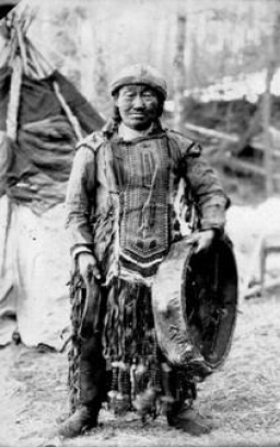
Figure 7-3
Tlingit Shaman from the Wrangell Area, c. 1899
Historical Alaska Native and Western Worldviews.
To further explore Dr. Kawagley’s elements of the Native worldview, lets compare it to
the historical Western worldview by asking several questions. If you were to select a tetrahedral
metaphor like Kawagley’s to illustrate the historical Western worldview, what would it look
like? Perhaps a better question is: Would it work at all? Can it be argued, for example, that the
“Natural Realm” (the natural environment) will not fit into any diagram attempting to represent
the historical Western worldview because it has not held nearly the same spiritual meaning as
found in subsistence-based Native societies? Please note that we say “historical Western
worldview,” not simply Western worldview. We do so because over the past several decades,
many Euro-Americans and others have become much more aware and protective of the natural
environment and its creatures. We see this in the growing political power of environmental and
animal rights groups. Historically speaking, however, Western man did not seek protection of the
natural world. In fact, quite the opposite is true as we will see shortly when we discuss the
doctrine of higher uses.
Alaska Natives and the natural world. The point
has been made several times that the quality of life in traditional Native
subsistence-based societies was almost totally dependent on a
people’s relationship to wildlife and their habitat. Therefore we should
not be surprised that the natural realm took on sacred meanings for Native
people who infused it with ceremony and
ritual. Why is the Raven the central figure in many traditional Native
beliefs about creation? Why do Iñupiaq whaling families traditionally give
a drink of fresh water to the head of a just butchered whale and other marine
mammals and push it back into the sea?9 Shortly
after killing a black bear, why do Koyukon Athabaskan men hold what
has been described as a potlatch-like
feast honoring the bear?10 Why are all
Tlingit clans totemic, with their clan crests showing a specific animal
as emblematic of the
clan’s mythical origins?
Totemism refers to the set of symbols
and rituals used by a kinship group to express their mythical relationship
to a natural object such as an animal or plant. This mythology is usually
found in the kin group’s creation stories. A totemic society is organized
into a fixed number of clans, each of which is represented by a totemic
figure. For the Tlingit, such totemic figures
were, among others, the killer whale. the beaver, and the salmon.
When we think of totemism, we usually have in mind the tall,
ornately carved Native poles of Southeast Alaska which depict the totemic figures
of a clan
or clan house along with other
symbolic representations of their historical legacy. However, according
to the late Tlingit writer, Andrew Hope III, “one often hears it said
by the older people that originally totem poles were used inside of houses
only, to support the huge roof beams.”11 Among
totemic societies in other parts of the world you don’t always
find striking monuments like totem poles depicting a clan’s
history and mythology. A good example is the clan systems of Australian
Aboriginal societies where their totemism is portrayed by other forms
of artistic expression.
Doctrine of Higher Uses. The traditional Native
view of the natural realm as sacred is quite at odds with the historical
Western worldview where, until recently, the basic theme has
been the belief that the natural environment exists to be exploited and changed
for human
material advantage. Most often Western man has viewed the natural environment
as an obstacle to overcome, not as sacred realm to be carefully used
and maintained. Declarations of a divine
inspiration to “tame the wilderness” occurred repeatedly during
the European colonization of the Americas. Many times this belief provided
justification for removing Native tribes from their
lands in order to advance the Western concepts of progress and Christian
civilization. Some scholars have fittingly called this attitude the doctrine
of higher uses. 12 Rather
than be left to the primitive pursuits of subsistence hunting and gathering,
the land and its resources must be put to
the “higher uses” of farming, ranching, industry, and commerce.
Anything less was often considered sinful idleness.
The doctrine of higher uses was well expressed in the ideology
of Manifest Destiny. By the 1840s Americans had come to believe it was manifestly
evident, even divinely justified, that
the United States was destined to expand across the continent to the Pacific,
bringing its grand experiment in democratic capitalism to the uncivilized
Native tribes. Americans – particularly
new European immigrants to America – were looking for fertile
lands west of the Mississippi to settle and cultivate. And American
merchants and manufacturers were searching for new raw
materials and markets. One of the best known Native American writers
is N. Scott Momaday, a Kiowa Indian from Oklahoma. He makes this point:
The Indian considers the land to be possessed of spirit, and his identity is bound
up in it. ‘Manifest destiny’ implies that the land can and must be appropriated for the sake
of expansion, empire building, profit. It is an enterprise without spirit, and not only
Indians have suffered from its unchecked pursuit.13
Historical Legacy and Worldview
Historical legacy: reality and myth. Dr. Kawagley
suggests that “myths” and “legends”
are a large part of any people’s worldview. We would add historical
legacy as also embedded in
the collective memory of every human group. It is that part of the group’s
past – most often a
heroic past – which is told and retold down through the ages to
the point where it can easily become the stuff of mythology and legend.
For every human group, whether traditional or
modern, the retelling of their historical legacy always has purposes
beyond mere presentation of facts. There are always cultural values
to be considered and lessons to be learned. Reflecting on
popular tellings of his culture’s history, the Irish writer, Sean
O'Faolain, reminds us that:
“History is ... an ever-developing process, and all its events not so
much events as thoughts hammered into mortal heads.”14
O'Faolain’s observation that over time the triumph
and tragedy of significant historical events and heroic figures are retold
in ways that remind adults and convey to youngsters the
essential aspects of their society’s core values and cultural identity.
It is “hammered into mortal
heads” by story telling, the construction of monuments, and through
ritual and ceremony. In recent times, for example, there has been much
public storytelling of the American experience in
World War Two. It is being hammered into our mortal heads.
World War Two – the Great American Historical Legacy. Starting
sometime in the late 1990s, World War Two storytelling seemed to surge with
the publication of, among others,
the bestselling books by the historian, Stephen Ambrose. Especially popular
were his D-Day,
June 6, 1944 and Band of Brothers. The D-Day book inspired the box
office hit and academy award winning movie, Saving Private Ryan.
The Band of Brothers book led to one of the most
widely watched television events in recent times — the ten part mini-series of the same title on
HBO. And published in 1998 was one of the all time bestselling books, The Greatest Generation,
by former NBC News anchor, Tom Brokaw. Using the living oral history
method, he interviews
fifty Americans from different walks of life who lived, worked, and fought
during World War Two. He suggests that they should be considered the
greatest generation because they changed
the course of American history with their courage, perseverance, and
sacrifice during the war. He also feels that they provided exceptional
leadership in countless ways after the war. Then in 2007
there was the seven part PBS documentary by Ken Burns entitled “The War” which, of course, is
WWII. Most recently in 2010, the producers of Band of Brothers had
another WWII mini series on HBO entitled The Pacific.
As for
monuments, all of this well crafted and immensely popular storytelling
led to the remarkably swift construction of the World War Two Memorial
in the heart of the Nation’s
capitol. It was opened to the public in April, 2004, only six years after Saving Private Ryan hit
the movie houses and the Greatest Generation hit the bookstores.
The Memorial was funded almost entirely by private contributions totaling
$195 million, a fact that certainly attests to the
emotional impact the retelling of this historical legacy has had on the
American imagination. Not surprisingly, the World War Two Memorial is
flanked by two other significant America
historical shrines, the Washington Monument to the east and the Lincoln
Memorial to the west. The very manner in which visitors conduct themselves
at America’s war memorials in
Washington D. C. tells us we are on hallowed national ground. It makes no difference if it’s the
Korean War Veterans Memorial, the Vietnam Veterans Memorial Wall, or the World War Two
Memorial. People move slowly and quietly and speak in hushed tones as if they were in church.
If America has a central spiritual place — a great outdoor national cathedral dedicated to what is
found sacred and glorious in the American spirit —it is these war memorials combined with the
nearby Presidential memorials, all of which are within walking distance of each other.
Along with the telling and retelling of stories and the construction
of monuments, there is constant ritual and ceremony to remind us of how the
historical legacy represented by war and
presidential memorials reflects the best of American values and traditions.
At major sporting events there is the singing of the national anthem or an
equivalent such as “America the
beautiful.” Often there is the presence of a military honor guard and the unfurling of the
American flag. The pledge of allegiance is recited by children and teachers at the start of the day
in many of the nation’s schools. And it should not surprise us that both Republicans and
Democrats at their national conventions spend less time on specific issues affecting people’s
everyday lives and more time on how they are better than the other party at representing the best
of the America historical legacy. The overriding convention message is that our political party’s
version of American history and what made this country great is better than the other party’s
version. Therefore our political party has proven best at advancing the ideals of freedom and
democracy and maintaining America’s leadership in the world.
Why World War Two? Why does the historical legacy of World War Two occupy such
a venerated place in the American worldview? Because for years to come it will provide the
perfect opportunity to reinforce our most cherished national self images. It was the right war
fought at the right time in the right place. Unlike other American wars, the morality of it — the
righteousness of its cause — was clear. A militaristic Japanese imperial government with its
“sneak attack” at Pearl Harbor and the monstrous purposes and actions of Nazi Germany make
them the perfect enemy. You cannot say enough bad things about them and, therefore, think
enough good things about us. It is, moreover, the retelling of a horrible history without horrible
consequences, at least from the American perspective. World War Two itself was surely brutal
on every front, with the Americans sustaining considerable loss of life and limb. But when
looking back, it is the triumph over just such brutal conditions which makes for an even more
uplifting historical legacy to be played over and over again down through the ages. It has become
a treasured legacy which blends fiction with fact to deepen its emotional appeal and highlight
cultural lessons to be learned.
Because we are all familiar with it, World War Two is chosen
here as an example of a historical legacy giving rise to a mythology which,
in turn, becomes part of a culture’s
worldview. That is, World War Two has transcendent cultural meaning. By “transcendent” we
mean the purpose for telling the history goes well beyond facts. Like the film Saving Private
Ryan, it is not always claimed that every part of the story is
true. Instead, it is told and retold because of what it says about
American traditions, values, and cultural identity. It is a historical
fact that there was no Private Ryan to be saved. But that’s not what is important about the film.
What is important are its searing images of extreme sacrifice and courage for what are
considered all the right reasons. The historical event’s people and actions become larger than life
and rise to the level of mythology, usually to the level of heroic mythology.
When World War Two is bundled together with other historical
legacies such as the Founding Fathers and their struggle for independence and
a constitutional democracy, we
glimpse the dominant American worldview and cultural identity. An example
of an Alaska Native world view shaped by historical legacy is the heroic exploits
of Yup’ik warrior
Apanuugpak during the 18th century Bow and Arrow Wars.15 Still
another example is the Kiks.a?Ldi clan’s survival march during the 1804 Tlingit – Russian war.16 So
when working on your cultural profile assignment, always keep in
mind this idea:
All societies and cultures down through time and around the world have historical
legacies as significant parts of their worldview and cultural identity.
Ideal Culture and Social Reality
A social contradiction without end. Another important reason for giving worldview
special attention is because it highlights the idea that all human societies operate on two levels.
There is the level of ideal culture where oral and written traditions, including historical legacies,
reflect what the group says are its most precious values. But there is also the level of social
reality where many times the everyday actions of people and institutions contradict the very
values declared to be most precious.
We know that many of the statements on human equality and liberty
in the American
Declaration of Independence and the Constitution’s Preamble and Bill of Rights have been
violated by real American history. Since the founding of the American nation, almost ninety
years of slavery and another eighty years of legally sanctioned racial segregation in mainly
southern states are obvious examples of such contradictions. ( 246 years of slavery if we count
from the time the first slaves were delivered to the Jamestown colony in 1619.) And of course
there is the shameful history of federal Indian policies and their often devastating consequences
for Native American tribes. It should not surprise us when many Native Americans become
irritated at the popular retellings of certain American historical legacies. The “discovery” sagas
of Christopher Columbus and the inflated one-sided storytelling of “Custer’s Last Stand” come
quickly to mind. In 2009 Congress finally admitted to this tarnished history by passing a joint
resolution formally apologizing to Native American tribes for a history of “official depredations,
ill-conceived policies and the breaking of covenants.” 17
In
all societies there always exists some gap or contradiction between
the ideal and the real simply because we are all imperfect humans operating
imperfect human institutions.
Fortunately this social fact has not kept courageous people from challenging
injustices by asking questions such as: Is the gap closing between
our ideals and how we actually conduct our real
life? Or is it getting wider? Do we have the legal means and the political
will to close the gap? But as the prominent American statesman and
two-time presidential candidate Adlai Stevenson
once said, “It is often easier to fight for principles than to live up to them.” Nevertheless, a strong
ideal culture can have the power to sustain people’s hope and
aspirations, even in the face of the most oppressive social realities.
Foundations of federal Indian Law: an ideal legal culture? In the United States there
is an ideal legal culture defining the rights of Native American tribes, including Alaska Natives.
This jurisprudence is found in the foundational principles of federal Indian law largely
established by three early Supreme Court decisions.18 Together, they are known as the “Marshall
Trilogy” because Chief Justice John Marshall wrote all three court opinions. Even today these
principles still furnish the essential standards for adjudicating major controversies over Native
rights. (From an Alaska perspective, federal Indian law could just as easily be called federal
Native law since Eskimos and Aleuts are equally subject to its rules.) Here are the principles in
brief:
- Tribes have a right of use and occupancy to their lands until clearly
extinguished by the federal government through a negotiated settlement.
As we have seen, this land-use right is
called “aboriginal title.
- Congress has plenary (complete)
power over Indian affairs. But this power carries with it the
clear obligation to protect tribal rights and resources from all others.
For example, Alaska or
any other state only has power over Native affairs when that
power
is clearly delegated to it by Congress.
- By the very fact of being
original occupiers of the land, tribes possess an inherent sovereignty.
Therefore the federal government cannot grant sovereignty to tribes because
tribes already possessed it before the United States existed.
Exercising its plenary power, Congress can, however, extinguish the sovereign
powers of tribes in all or in part. Indeed,
much of the history of federal Indian law and policy is marked
by a continual diminishment
of tribal lands and self-governing powers by Congress and the courts.
This is what the Native American rights lawyer Walter Echo-Hawk (Pawnee)
calls the “dark side of federal Indian
law.” 19
- And, finally, federally
recognized tribes have a special relationship of one sovereign
to another with the United States government. Of course the federal
government is the ultimate
sovereign, but certain sovereign rights and immunities are
retained by tribes. Note that within the American Republic, there
are only three political entities having the power to exercise
sovereign authority – the federal government, the fifty
states of the Union, and Native American tribes.
So whenever Native American tribes argue for their rights in court or in Congress, the
driving idea behind their argument is: “These are your own American laws. All we ask is that
you abide by them”! By invoking one or more of these foundational principles, tribes seek to
expose what they view as the gap between an American legal ideal and whatever perceived
challenge to Native rights they confront at the moment. Of course tribes do not always prevail.
If, however, there was no ideal legal culture to call upon, tribal arguments would have little
chance of being heard let alone a chance of success. To understand the significance of these
federal Indian law principles as ideal legal culture, we now look at the contrasting case of
Aboriginal tribes in Australia.
Australian Aborigines: a contrasting Native rights situation. In
sharp contrast to the ideal culture of American Indian law is the uncertain
legal status of Aborigines, the indigenous
people of Australia. Unlike the United States, there is no historically developed
legal doctrine defining Aboriginal land rights and tribal sovereignty in Australia.
Even today, Australian
Aborigines cannot say, “These are your own Australian laws. All we ask is that you abide by
them”!
Geographically, Australia is the sixth largest nation in the
world. It has, however, a relatively small population of 20 million. The Australian
federation consists of six States and two
federal Territories. The Aboriginal population is estimated to be about
500,000, or about 2.5% of the total population. Before the arrival of Europeans,
Aboriginal tribes occupied most areas of
the Australian continent. Scientific studies indicate that they had inhabited
Australia for at least 20,000 years before European contact. In 1770, Captain
James Cook landed on the east coast of
Australia and claimed the continent for the British Crown. By 1790 the
non-Aboriginal immigrant population rose to about 160,000. Then in the 1850s,
the growth of the wool industry
and gold rushes led to a new wave of immigration to the Australian colony.20
Like
the white settlers who invaded Indian country in the American West, the
early colonists in Australia desired large tracts of land for farming,
livestock raising, and mineral
development. But unlike American settlers who were often confronted by large,
powerful Indian tribes, the Australian colonists encountered far less
threatening small, nomadic hunter-gatherer
groups scattered throughout the continent. They quickly sought to bar any
possible Aboriginal land claims by declaring Australia to be terra nullius,
which means “empty land” in Latin.
According to European-made international law of the time, a nation could
claim a right of discovery to empty wilderness lands not already claimed
by another nation. By the end of the
18th century, however, the terra nullius doctrine was expanded
to include lands occupied by “uncivilized tribes” described
by European colonizers as lacking any real legal system, hence any land
tenure rules to be respected.
Figure 7-4
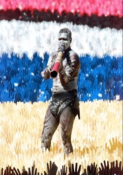
Australian Aborigine,
Djakapurra Munyarryun, plays the didgeridoo in the "Sea of Hands" display
in Sydney in 1998. The display was in support of native title and reconciliation
of Australian aboriginals.
(Source:AP)
For two hundred years terra nullius survived as Australian legal doctrine automatically
extinguishing whatever Aboriginal rights to land and sovereignty might be claimed. Then in
1992 the Australian High Court agreed to hear an Aboriginal challenge to terra nullius. The
Court ruled in Mabo v. Queensland that indeed terra nullius had been wrongly applied from the
very beginning. As the High Court’s Chief Justice Gerrard Brennan put it, "The fiction by which
the rights and interests of indigenous inhabitants in land were treated as non-existent [and]
justified by a policy [of terra nullius] ... has no place in the contemporary law of this country."21
But did striking down terra nullius as legal doctrine
mean Australian Aborigines now have recognized rights to land and sovereignty
approaching that of American tribes?
Unfortunately it did not. While the High Court’s decision in Mabo held that the declaration of
terra nullius did not extinguish Native title, it also said that other actions by the British Crown
over the years may have the power of extinguishment. The Court held that as ultimate sovereign
of Australia, any grants of land made by the Crown to non-Aboriginal private or public interests
are likely to be valid acts extinguishing any Aboriginal claims to the same land. In a word, much
of what the High Court gave with one hand, it seemed to take away with the other hand.
Ideal legal culture – a final comment. Western
democracies such as the United States and Australia claim to cherish
the Rule of Law, which usually means a well defined
jurisprudence fairly and equally applied to all. It is the law and
not the prejudices and self interests of men that should prevail. But
obviously there first has to be a body of law to cherish,
to abide by. In the United States we have the foundational principles
of federal Indian law. In Australia there is no such body of law – there is no ideal legal culture to call upon.
When they reflect the best standards and traditions of a society’s
ideals, there is simply no substitute for the protections offered
by established legal doctrine. Previously the late
Standing Rock Sioux scholar Vine Deloria Jr. introduced us to the Ex Parte Crow Dog case
and elements of the Sioux system of justice. Most likely the general
public knows him best as a harsh
critic of United States Indian policy and law. His first book, Custer Died for Your Sins,
disturbed many people. It was, nevertheless, a nationwide best seller
in the 1970s. Yet even Deloria
concedes that “in spite of the history of exploitation and conquest represented by American
settlement of North America, American Indians have actually been treated considerably better
than any other aboriginal group on any other continent.”22 Interestingly,
when ruling on important Native rights issues in their own countries,
both Australian and Canadian courts have
directly referred to those early United States Supreme Court decisions
establishing the fundamentals of federal Indian law.
Review Questions
According to Oscar Kawagley, what are the major elements of the
traditional Alaska Native worldview?
How does the traditional Alaska Native worldview differ from the
historical Western worldview?
Although performed by just one person, why do we consider
shamanism to be a multi-functional institution?
Why do we include historical legacy as an essential part of any
culture’s worldview?
How does the historical legacy of World War Two transcend fact
and take on a larger, almost mythological meaning within the
American worldview?
Why is it important to understand that all societies have both an
ideal culture and an often contradictory social reality?
Aborigines make up 2.5% of the Australian population. Native
Americans make up only 1% of the United States population. Yet
Native Americans have far more self determination than
Aborigines. Why?
ENDNOTES
-
Carlos Frank v. State of Alaska, Supreme Court of
Alaska (1979.AK.224).
-
Sherbert v. Verner (374 U.S. 398) 1963, and
Wisconsin v. Yoder (406 U.S. 205) 1972.
-
Oscar Kawagley, A Yupiaq
Worldview (Illinois: Waveland Press, 1995) pp. 8 - 9.
-
Mary Muktoyuk,
Iñupiaq Rules for Living. Anchorage: AMU Press. Found
in Kawagley, pp. 9-10.
-
Ann Fienup-Riordan, “Eye of the Dance:
Spiritual Life of the Bering Sea Eskimo”’ in W.
Fitzhugh & A Crowell
(eds.), Crossroads of Continents, pp. 267-269.
-
Shaman Khorolkan
of the Kambaghir tribe of the Evenk, first quarter of the
19th century. See: Solovyova, Karina, “Shamanism among
the peoples of western and Eastern Siberia” Russian
Museum of Ethnography at About.com
-
Anna Reid, The Shaman’s
Coat: A Native History of Siberia, Walker Publishing Co.
2003, pp. 4-5
-
Rosita Worl, “The I`xt’: Tlingit
Shamanism,” Celebration
2000, Sealaska Heritage Foundation, 2000, pp. 155-172.
-
Steve Landon, The Native People of Alaska (Anchorage: Greatland Graphics,
2002) p. 77.
-
Richard K Nelson, Make Prayers to the Raven, (Chicago:
University of Chicago, 1983) p. 20.
-
Andrew Hope III, “Southeast Region: Reading Poles” in
Sharing Our Pathways, A newsletter of the Alaska
Rural Systemic Initiative. Volume 3, Issue 5, 1998.
-
See: Robert
Berkhofer, The White Man’s Indian: Images of the
American Indian from Columbus to the present ( New York: Vintage Books – Random
House, 1979).
-
E-mail message to the editors of the New York Times
Book Review, October 29, 2006, p.6.
-
John Water, Jiving at
the Crossroads (Dublin: Blackstaff Press, 1991) Flyleaf.
-
Ann Fienup-Riordan, “Robert Redford, Apanuugpak,
and the Invention of Tradition” , Études
Inuit,
11, 1987.
-
Herb Hope, “The kiks.a?Ldi Survival March of 1804” in
Andrew Hope III and Thomas F. Thornton,
Will the Time Ever Come: A Tlingit Source Book (Fairbanks:
Alaska Native Knowledge Network, 2000). Online
at www.Alaskool.org
-
Senate Joint Resolution 14, signed into law
by President Barack Obama, December, 2009.
-
Johnson v. McIntosh,
22 U. S. ( 8 Wheat.) 543, 1823; Cherokee Nation v.
Georgia,
30 U. S. ( 5 Pet.) 1, 1831; Worcester v. Georgia, 31 U.
S. ( 6 Pet.) 515, 1832.
-
Walter Echo-Hawk, In the Courts of
the Conqueror: the 10 Worst Indian Law Cases Ever Decided (Golden, Colorado: Fulcrum Publishing, 2010).
-
Go to: About
Australia. Com
-
Mabo v. Queensland (No 2) , 1992, HCA,
23.
-
Deloria Jr., Vine & Lytle, Clifford, The
Nations Within, University of Texas Press, 1998,
p. 2.
Table of Contents | Chapter
8
 The
University of Alaska Fairbanks is an Affirmative
Action/Equal Opportunity employer, educational
institution, and provider is a part of the University of Alaska
system. Learn more about UA's notice of nondiscrimination. The
University of Alaska Fairbanks is an Affirmative
Action/Equal Opportunity employer, educational
institution, and provider is a part of the University of Alaska
system. Learn more about UA's notice of nondiscrimination.
Alaska Native Knowledge
Network
University of Alaska Fairbanks
PO Box 756730
Fairbanks AK 99775-6730
Phone (907) 474.1902
Fax (907) 474.1957 |
Questions or comments?
Contact ANKN |
|
Last
modified
July 6, 2011
|
|